

Type in search terms.
SECTION 1: INTRODUCTION
Webequie Supply Road Project
May 1, 2025
AtkinsRéalis Ref: 661910
Draft Environmental Assessment Report / Impact Statement
SECTION 1: INTRODUCTION

Contents
- Introduction……………………………………………………………………………………………………………………… 1-3
In Text Figures
Figure 1.1: Project Location…………………………………………………………………………………………………………… 1-5
Figure 1.2: Project Main Components……………………………………………………………………………………………… 1-6
Figure 1.3: Location of Ring of Fire Area…………………………………………………………………………………………. 1-14
Figure 1.4: Coordinated Webequie-Federal-Provincial EA/IA Process……………………………………………………. 1-20
In-Text Tables
Table 1-1: Proponent Contact Information……………………………………………………………………………………….. 1-7
Table 1-2: Federal Legislation, Permits, and Other Authorizations……………………………………………………….. 1-20
Table 1-3: Provincial Legislation, Permits, and Other Authorizations…………………………………………………….. 1-21
Appendices
A1: Table of Concordance with Tailored Impact Statement Guidelines
A2: Table of Concordance with Provincial Environmental Assessment Terms of Reference B: Qualifications and Roles of the Project Team Members
1. Introduction
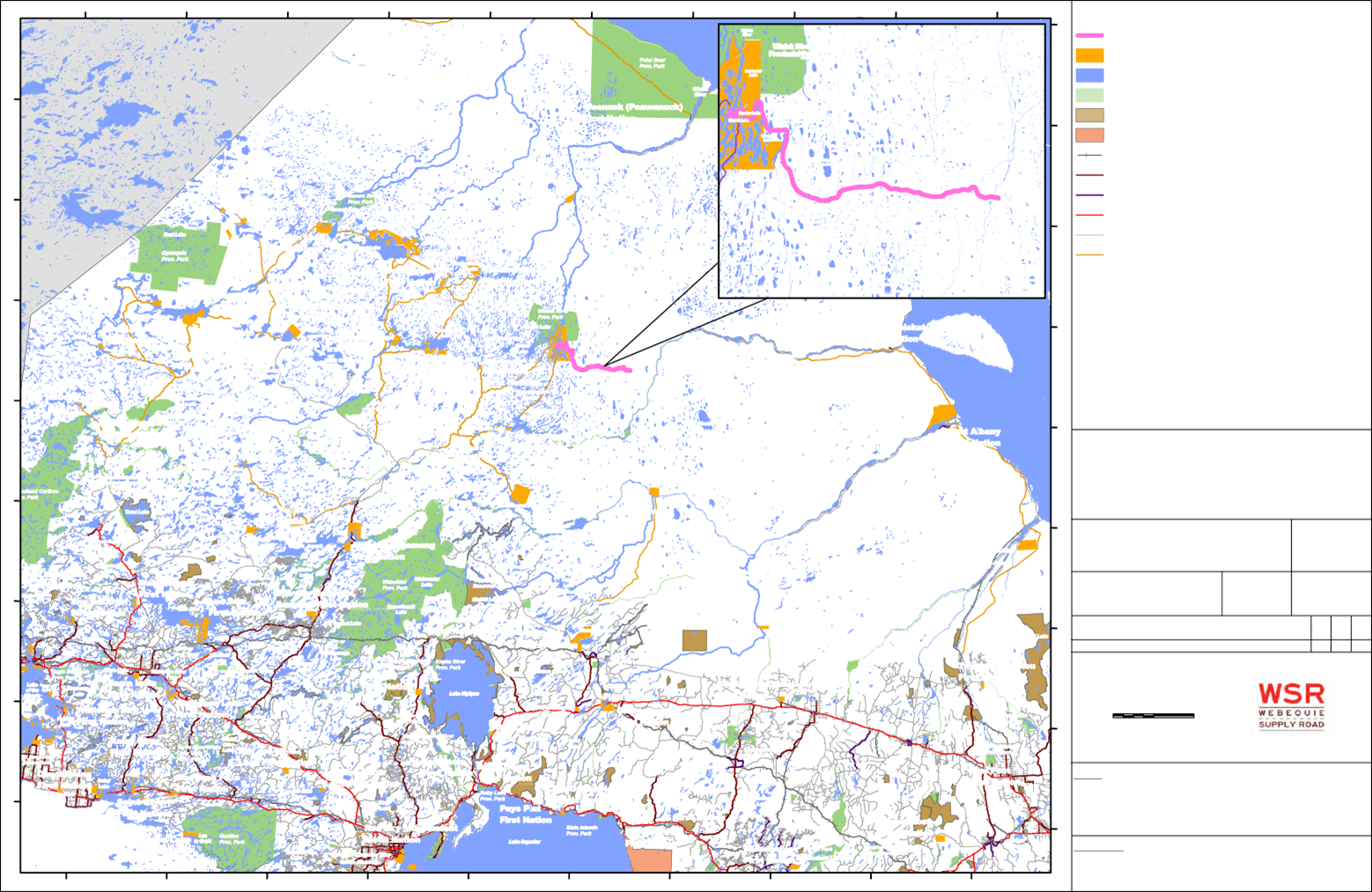
Webequie First Nation is completing an Environmental Assessment (EA) under Ontario’s Environmental Assessment Act (EA Act) and Impact Assessment (IA) under Canada’s Impact Assessment Act (IA Act) for the proposed Webequie Supply Road (“the Project”, WSR). The proposed Project is a new all-season road of approximately 107 kilometres (km) in length, connecting Webequie First Nation and its airport to existing mineral exploration activities and proposed future mining development in the McFaulds Lake area. The location of the Project is approximately 525 km northeast of the City of Thunder Bay in northwest Ontario, as shown on Figure 1.1.
This document is the Draft Environmental Assessment Report/Impact Statement (EAR/IS) for the proposed WSR. The Draft EAR/IS is being submitted by Webequie First Nation, as the proponent, to the Impact Assessment Agency of Canada (IAAC or the Agency) pursuant to requirements of the federal IA Act and Tailored Impact Statement Guidelines (TISG) for the Project, dated February 24, 2020 (IAAC, 2020; Appendix A-1). In addition, the document is also being released for review and comment to Indigenous communities, the public, government agencies, and stakeholders by the proponent (i.e., Webequie First Nation) pursuant to the requirements under the Ontario EA Act and the Terms of Reference (Webequie First Nation, 2020; Appendix A-2), which was approved by the Minister of Environment, Conservation and Parks on October 8, 2021.
1.1 Project Overview
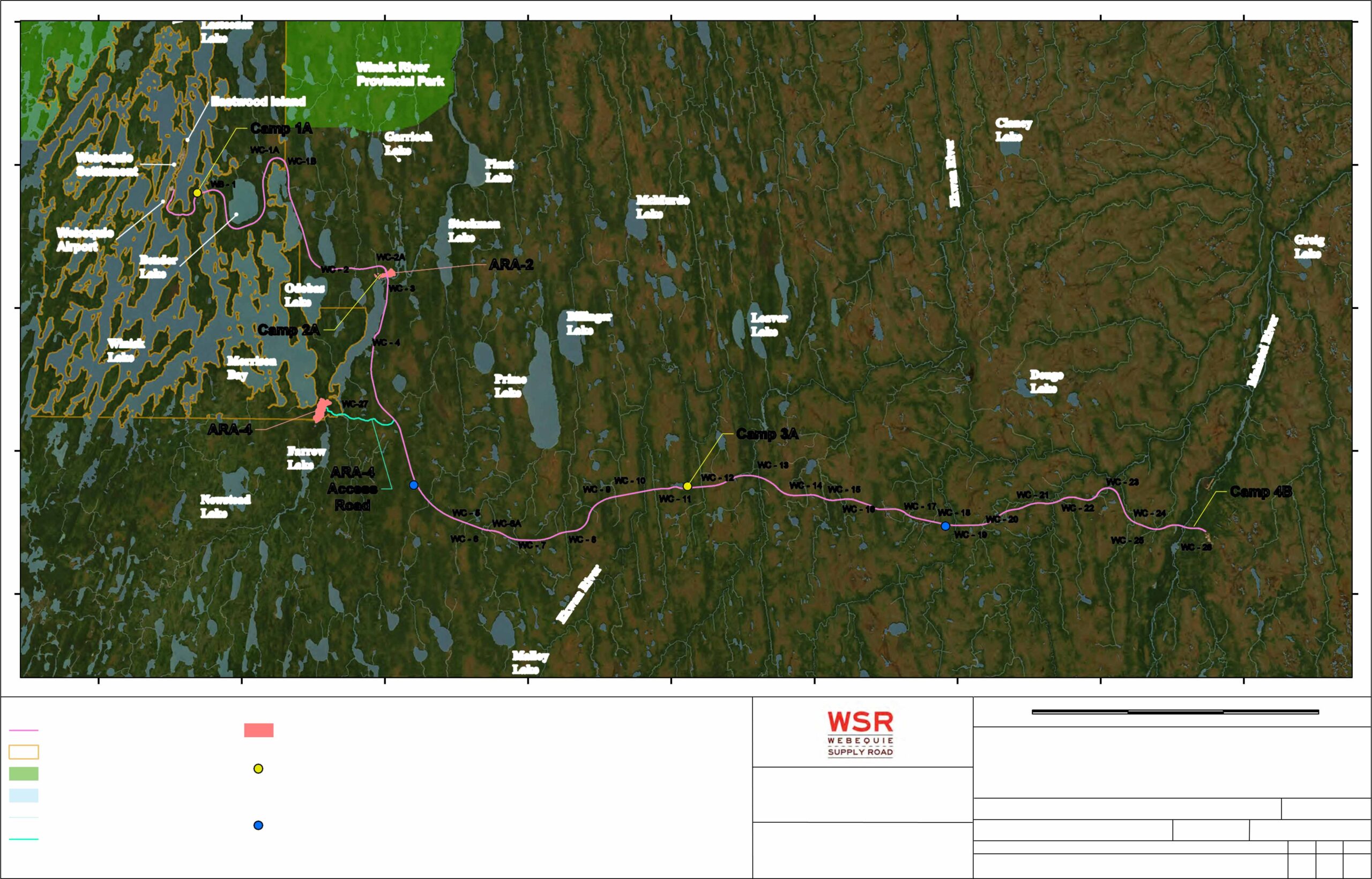
The proposed WSR is a new two-lane all-season road within a cleared right-of-way (ROW) of approximately 35 metres
(m) in width and approximately 107 km in length. The preliminary recommended preferred route for the road consists of a northwest-southeast segment running 51 km from the Webequie First Nation Reserve to a 56 km segment running east-west before terminating near the McFaulds Lake within the mineralized deposit area known as the Ring of Fire. A total of 17 km of the WSR is within the Webequie First Nation Reserve lands, with the remainder of the road located on un-surveyed Ontario Crown lands.
The Project includes the following main components.
- Permanent two-lane all-season road with roadside ditches within a typical 35 m ROW.
- Development of maintenance areas along the WSR to allow for equipment/vehicles during the operations phase of the Project to safely turn around.
- Development of rest areas along the WSR to enhance safe travel and provide more comfort for road users during the operations phase of the Project.
- Construction, operations and maintenance of 31 waterbody crossings, which include 6 bridges and 25 culverts.
- Development of temporary supportive infrastructure associated with construction, including:
- Aggregate/rock source areas (pits/quarries).
- Temporary access roads.
- Construction camps with laydown, and storage areas, including power supply and communication system.
- Development of a permanent Maintenance and Storage Facility (MSF), aggregate pit/quarry with access road, power supply and communications, and storage areas for fuels, explosives, equipment, aggregate and wastes to support operations and maintenance of the Project.
Figure 1.2 illustrates the project components that include the preliminary recommended preferred route for the WSR and locations of supportive infrastructure needed for construction and operations of the Project.
The Project will be designed, constructed and operated according to design codes, standards and guidelines applicable to Ontario highway projects. The design standards for the WSR are consistent with those used by the Ontario Ministry of Transportation (MTO) for similarly classified roads in the northeast and northwest regions of the province and is classified as a Rural Collector Undivided facility, The specific applicable MTO design criteria, standards and guidelines applied to the Project are detailed in Section 4 – Project Description.
The Project is planned to occur in two main phases as described below:
- Construction Phase: All the activities associated with the initial development of the road and supportive infrastructure from the start of construction to the start of operations and maintenance of the WSR. The construction phase is anticipated to take approximately 4 to 6 years to complete.
- Operations Phase: All activities associated with operations and maintenance of the road and other permanent supportive infrastructure (e.g., MSF, pits/quarries) that will start after construction and will continue for the life of the Project. The operations and maintenance phase of the Project is considered to be 75-years based on the expected timeframe when major refurbishment of the road components (e.g., bridges, culverts) is anticipated.
There are no proposed plans to decommission the WSR and the Project is proposed to be operated for an indeterminate time period. Therefore, future suspension, decommissioning and eventual abandonment will not be considered in the Environmental Assessment/Impact Assessment (EA/IA) for the Project. Should a decision be made to decommission the Project in the future, a detailed review of the potential effects and mitigation measures will be completed.
Decommissioning will be planned and conducted in accordance with the relevant standards and regulatory requirements in effect at that time.
Based on the low population density in the project study area and the intended stated purpose of the WSR (refer to Section 1.3.2), an average annual daily traffic volume of less than 500 vehicles has been projected for the Project. It is expected that traffic during the operations phase will comprise primarily of light to medium personal and commercial vehicles, with some limited heavier truck traffic carrying industrial (mining) supplies and equipment. The WSR traffic operations is not anticipated to include mineral ore or mine product hauling/transport.
At this time there are no proposed access controls for road users of the WSR, such as who will be allowed to use the road and under what conditions, however the topic of controls is subject to further discussion and agreement between Webequie First Nation and the Province of Ontario in future development phases of the Project after the EA/IA process. How, and if, access controls will be executed and enforced will be a function of road ownership and jurisdictional aspects of road operations. It will be particularly important to clarify this for the portion of the roadway that will cross Webequie First Nation Reserve lands, which fall under federal jurisdiction.
1.1.1 Project Location
The Project is located in northwestern Ontario on un-surveyed Ontario Crown lands and Webequie First Nation Reserve lands (refer to Figure 1.1 and Figure 1.2).
The coordinates of the proposed project area are as follows:
- West limit in the vicinity of: Latitude: 52 degrees 56 minutes 50.32 seconds
Longitude: 87 degrees 21 minutes 19.79 seconds
- East limit in the vicinity of: Latitude: 52 degrees 44 minutes 54.50 seconds
Longitude: 86 degrees 18 minutes 32.61 seconds
1.2 Project Proponent
1.2.1 Proponent Contact Information
Webequie First Nation is the proponent of the WSR for the purposes of the EA/IA and associated early planning and design of the Project. The proponent for the construction, and operations and maintenance phases of the Project are not known at this time and is part of future discussions and agreement between Webequie First Nation and the Government of Ontario.
Contact information for the proponent is summarized in Table 1-1. Table 1-1: Proponent Contact Information
| Project Name: | Webequie Supply Road |
| Project Proponent: | Webequie First Nation |
| Proponent Contact Information: | Chief Cornelius Wabasse Webequie First Nation P.O. Box 268 Webequie, ON P0T 3A0 Phone: 807-353-6531 Fax: 807-353-1218 E-mail: info@webequie.ca |
| Principal contacts for the purposes of the Environmental Assessment/Impact Assessment: | Michael Fox Regional Consultation Lead Webequie First Nation 1000 Chippewa Road Thunder Bay, ON P7J 1B6 Tel: (807) 472-6147 Fax: (807) 577-0404 E-mail: michael.fox@supplyroad.ca Craig Wallace Project Manager AtkinsRéalis 191 The West Mall Toronto, ON M9C 5K1 Tel: (416) 252-5315 Fax: (416) 231-5356 E-mail: craig.wallace@atkinsrealis.com |
| Project Website | www.supplyroad.ca |
1.2.2 Overview of Webequie First Nation
Webequie First Nation is an Ojibway community located about 525 km north of the City of Thunder Bay in northwestern Ontario with a population of 976 (CIRNAC, 2023), of which 821 are registered as on-reserve. Webequie is a fly-in remote community with a seasonal winter road used for access during the months of January and February. The community is located on the northern peninsula of Eastwood Island on Winisk Lake in the upper reaches of the
Winisk River (refer to Figure 1.2).
Webequie First Nation’s homeland makes up part of the traditional Oji-Cree territories that are located in the central expanse of northern Ontario. The traditional language spoken in Webequie is Oji-Cree, a dialect of Anishinaabe with influences from the Cree language and is considered a distinct language and culture (CBC, 2023).
Webequie is an Ojibway word with the meaning “shaking head from side to side”. The community received the name many years ago and has a special meaning to its people (Webequie First Nation, 2023a). According to the community the origin is as follows (Webequie First Nation, 2023a):
“The story goes, that early one morning a long time ago, a community member was paddling his canoe out onto the lake. He noticed a family of mergansers attempting to take flight and running across the calm surface. It was a very calm day, and there was no wind to help them get airborne. In their frantic attempt to get some lift, the man observed they were shaking their heads from side to side, looking for a breeze. This is how our name originated, and why we have a merganser as part of our community logo”.
Webequie First Nation is a Nishnawbe Aski Nation (Treaty No. 9) First Nation (Nishnawbe Aski Nation, 2023).
Treaty No. 9 was first signed in 1905-1906 and adhesions signed in 1929-1930. At the time, the Crown included clans representing the Webequie community with the Eabametoong (Fort Hope Band) (Archaeological Services Inc., 2021). In the post-Treaty years, Webequie First Nation was not recognized as having Band status until 1985 when this was received from the federal government. Although Webequie was recognized as a settlement, it did not have reserve lands allocated officially, and therefore having only a Band Registration number did not give Webequie reserve status, or the many associated benefits. Webequie continued to pursue reserve lands, which were finally granted in 2001 (Webequie First Nation, 2019).
Webequie First Nation indicates it has inherent right to self-governance and self-determination (Webequie First Nation, 2023b). The elected Chief and Councillors are the recognized political representatives and leadership of the community. Webequie is committed to preserving its freedom, to live their lives as they choose, and to be proud of its heritage, and the strong and thriving community that has been built (Webequie First Nation, 2023b).
Webequie First Nation has a Custom Electoral System, with one Chief, one Head Councillor and five Councillors elected every two years (CIRNAC, 2023). Custom election processes follow community’s election code that provides the rules under which chiefs and councillors are chosen for those First Nations who are not under the Indian Act election rules. These codes are often unique to the specific community (Indigenous Services Canada [ISC], 2023).
Webequie First Nation has a rich history of close relations and family ties with neighbouring communities. The community is formally affiliated with political territorial organizations with common goals and interests. Webequie First Nation is affiliated with:
- Nishnawbe Aski Nation;
- Matawa First Nations;
- Chiefs of Ontario; and
- The Assembly of First Nations.
1.2.3 Webequie Project Team and Elders’ Guiding Principles
Webequie First Nation has established a Webequie Project Team (WPT) to guide and provide strategic advice and community perspectives to the consultant Project Team (led by AtkinsRéalis) conducting the EA/IA for the Project. The WPT consists of community members and elected councillors and report directly to Chief and Council on progress of the Project at key milestones and decision-making points in the EA/IA process.
Guidance to the WPT is being provided by Webequie Elders. This guidance will ensure that the Webequie First Nation conducts consultation/engagement for the Project in a respectful manner that reflects the culture and traditions of the Webequie People and their clans and neighbours outside Webequie First Nation.
The WPT has been and continues to facilitate all project-related engagement and consultation activities to be inclusive of the following guiding principles:
- Mutual recognition of Nation to Nation;
- Mutual recognition of ancestral knowledge;
- Mutual recognition of traditional knowledge and practices;
- Mutual recognition of clan families and relationships;
- Mutual recognition of sustainable livelihood; and
- Mutual recognition of traditional protocols.
Webequie First Nation have developed a three-tier framework for their approach to Indigenous consultation. The three- tier approach is consistent with the Webequie First Nation’s traditional cultural values, customs and beliefs. Webequie is taking a unique approach that is based on not only their Elders but modern-day protocols in terms of how they engage with the public and also fellow Anishinawbek, Cree and Oji-Cree Peoples. The approach respects multiple aspects of what makes a community work well and relates to how its members see the world and can best benefit from roads, resource development and ownership of their land. Further details on the three-tier approach are described in Section 2.
1.2.4 Project Team
This Draft EAR/IS was prepared by AtkinsRéalis (the Project Team) with the assistance of other professional consulting firms. The qualifications and roles of the Project Team members are provided in Appendix B.
1.2.5 Proposed or Anticipated Financial Support
The federal government, through the Agency’s Participant Funding Program, is granting funding to eligible Indigenous communities identified by the Crown as potentially being impacted or interested in the Project to support their participation in the IA process for the Project.
The Province of Ontario is providing support and resources for Webequie First Nation to plan the proposed WSR, including conducting the coordinated federal IA and provincial EA in accordance with the Memorandum of Understanding between Ontario and Webequie First Nation that identifies the roles and responsibilities with respect to the procedural aspects of consultation on the Project. The province is also providing capacity funding, in the form of partnership funding agreements, for eligible Indigenous communities to participate in the provincial EA process, including sharing Indigenous knowledge and land and resource use information.
Federal and/or provincial funding for construction and operation of the WSR is yet to be determined.
1.3 Background and Purpose of the Project
1.3.1 Background and Context
To provide context and background for the proposed development of the Project, it is important to understand the various road/transportation studies undertaken by Webequie First Nation and others that have been completed in the region. These studies included:
- Winter Road Re-Alignment Study (2008);
- Cliffs Ferroalloys Black Thor Mine Integrated Transportation System (2011);
- Noront Resources Eagle’s Nest Mine Access Road (2013);
- All-Season Community Road Study (2016);
- All-Season Community Road Study – Phase 2 (2017);
- Marten Falls Community Access Road (2018, on-going); and
- Northern Road Link (2021, on-going).
All of these studies provide context for the proposed development of the Webequie Supply Road, with the overarching goal of Webequie First Nation to bring socio-economic opportunities and benefits to its community members and
local businesses. A brief description of the relevant studies is presented in chronological order below.
Winter Road Re-Alignment Study (2008)
On behalf of five First Nations (Marten Falls, Eabametoong, Neskantaga, Nibinamik and Webequie), the Matawa First Nations Tribal Council conducted a study in 2008 to examine realigning selected sections of winter roads. A number of the winter roads for consideration in the study were in the vicinity of the current project area for the WSR. The study included extensive consultation with the First Nations, regulatory agencies and other stakeholders (e.g., forestry companies and outfitters) and identified a number of alternative solutions (e.g., improvement to road design and construction standards) to address deficiencies in the winter road system.
From the Webequie First Nation perspective, this study was helpful in providing guidance towards improving existing winter roads that run to the south and west of the community. However, it did not examine a supply road connection into the McFaulds Lake area, which was considered important to Webequie First Nation, as it could provide broader economic development opportunities and social benefits.
Cliffs Ferroalloys Black Thor Mine Integrated Transportation System (2011)
In 2011, Cliffs Natural Resources (“Cliffs”), announced its intention to move forward with permitting and development of the Black Thor Chromite Mine in the McFaulds Lake Ring of Fire area. As part of the Black Thor Chromite Mine study, Cliffs developed an Integrated Transportation System (ITS) that optimized all-season road connection of the Black Thor mine assets and facilities with the provincial highway system and the CN Rail system at Highway 584 near Nakina.
Around the same time, KWG Resources (KWG), also active in the McFaulds Lake area, studied transportation options into the Ring of Fire area and identified a preference for a rail/road link that followed a similar route to the Cliffs proposed road route.
From the Webequie First Nation perspective, the preferred ITS selected by Cliffs did not include winter road or all-season road connection to Webequie, thereby limiting the potential for the community to transport goods and services to the mine development area and potential for connection to the provincial highway system.
Noront Resources Eagle’s Nest Mine Access Road (2013)
In 2013, Noront Resources prepared a draft federal/provincial Environmental Impact Statement/Environmental Assessment Report (EIS/EAR) for their proposed Eagle’s Nest mine in the McFaulds Lake area, including an examination of alternative road routes and types (e.g., winter, all-season and combined winter/all-season) that would connect the mine to the provincial highway system. The Noront draft EIS/EAR process was not completed. The provincial notice of approval for the Noront EA Terms of Reference for the Eagle’s Nest Mine Project included the requirement that Noront re-screen four road routes before reaching a conclusion on its access road route. The draft EIS/EAR for the Noront Eagle’s Nest Mine Project was prepared in advance of the approval of its Terms of Reference and does not reflect the requirement to re-screen access road routes. The Ontario Ministry of the Environment, Conservation and Parks (MECP) Environmental Assessment Permissions Branch did not review the draft EIS/EAR. The Project Team understands that the document was reviewed by federal agencies and comments were returned to Noront. As part of the transition to the new Impact Assessment Act on August 28, 2019, the IAAC issued a Notice of Termination of the federal EA for the Eagle’s Nest Mine Project.
The federal/provincial EA work undertaken by Noront up to 2013 does provide relevant context on the alternative road routes considered in the study area for the WSR (refer to Section 3). In identifying route alternatives for the Eagle’s Nest mine access road, it was Noront’s intention in 2013 to maximize the use of existing winter road routes and thereby minimize additional clearing and environmental effects. From this assessment, the preferred route was identified as an east-west connection via Webequie First Nation to the Northern Ontario Resource Trail (NORT) North Road/Pickle Lake Road and Highway 599 near Pickle Lake. This access road route provided potential all-season access to the provincial highway system for Webequie First Nation and other First Nations, including the Nibinamik, Neskantaga and Eabametoong First Nations.
From the Webequie First Nation perspective, this route provided community benefits by having an all-season access to the provincial highway system. In addition, the community would have potential economic development opportunities related to the transportation of goods and services between Webequie and the mine development area.
All-Season Community Road Study (2016)
Webequie First Nation, in partnership with three other First Nations (Neskantaga, Nibinamik and Eabametoong), completed the All-Season Community Road Study (ASCRS) in June 2016. The purpose of this study was to examine options for interconnecting these First Nation communities to the provincial highway system, with the goal of providing community social and economic benefits. Many alternatives were examined, including those previously preferred by Noront Resources, Cliffs and KWG Resources.
From the community engagement and assessment completed, a preferred route was identified with a general east-west orientation that connected the four communities to the provincial highway system. The preferred road from the 2016 ASCRS did not connect to the McFaulds Lake area due to unresolved issues and concerns expressed by some participating First Nations about mining development in the Ring of Fire area.
From the Webequie First Nation perspective, the preferred alternative emerging from the 2016 ASCRS provided a number of social and economic benefits, including the interconnection with other First Nation communities. However, there was additional interest in continuing to examine a supply road connection into the McFaulds Lake area. The connection between Webequie and McFaulds Lake is considered important to Webequie First Nation, as it could provide broader economic development opportunities and social benefits above and beyond the benefits of an
all-season community road to Pickle Lake.
All-Season Community Road Study – Phase 2 (2017)
In 2017, the Nibinamik and Webequie First Nations continued the ASCRS on their own to refine the preferred route analysis from the previous phase of the study. The ASCRS – Phase 2 involved many discussions with Nibinamik and Webequie land users, Elders and youth to refine the route centreline and to determine support for an east-west connection to the provincial highway system at the NORT North Road/Pickle Lake Road. The Phase 2 study also included more extensive data collection, including field studies and gathering of more Indigenous knowledge information. The Phase 2 study identified a refined east-west all-season road route, which has essentially the same purpose of connecting Webequie and Nibinamik to the provincial highway system at Pickle Lake.
From the Phase 2 study, it was determined there is reasonably strong support for an all-season community road to the provincial highway system, but not clear and full community support amongst all potentially affected First Nations for interconnection of the all-season road to proposed mining activity in the McFaulds Lake area.
From the perspective of the Webequie First Nation, there was general community and political support for an all-season community road connection to the provincial highway system. However, there was concern that the discussion of the
all-season road did not include an extension from the community eastwards to McFaulds Lake, which was thought to provide potential for greater economic development opportunities associated with the proposed mine exploration and future mining operations.
The above studies, as background and context, provide the foundation and rationale for the development of the proposed WSR. In particular, the ASCRS and refined Phase 2 study helped to guide Webequie First Nation to identify the current preliminary recommended route for the WSR, including consideration of alternatives in the EA/IA. In overview, the studies examined alternative road connections between the provincial highway system near Pickle Lake, several First Nations to the north, and the proposed Eagle’s Nest mine in the McFaulds Lake area.
Marten Falls Community Access Road and Northern Road Link (2018 and 2021)
In 2018, studies were initiated to further examine an all-season road interconnection between Nakina (near Geraldton) in the Greenstone Region and Marten Falls First Nation. Out of these studies Marten Falls First Nation is currently leading a coordinated federal-provincial environmental/impact assessment process for the Marten Falls Community Access Road (MFCAR), which would connect Marten Falls First Nation to the provincial highway network via a connection to Painter Lake Road. This EA/IA is on-going at the same time as the Webequie Supply Road EA/IA. In addition, as a separate project, Marten Falls First Nation and Webequie First Nation in 2021 initiated a federal-provincial EA/IA for an all-season road that would link the MFCAR and WSR, referred to as the Northern Road Link (NRL) project. The purpose of the NRL project is to: connect the Ring of Fire mineral deposit in the McFaulds Lake area to the highway network via MFCAR; provide an opportunity to connect Webequie First Nation to the highway network; and to enable a broader range of economic activity by facilitating the transport of goods, services and resources.
1.3.2 Purpose and Rationale for the Project
The purpose of the proposed Webequie Supply Road is to:
- Allow for the movement of materials, supplies and people from the Webequie First Nation’s Airport to mineral exploration and proposed future mine developments in the McFaulds Lake area;
- Provide employment and other economic development opportunities to Webequie First Nation community members and businesses that reside in or around the community’s reserve and traditional territory, while preserving their language and culture; and
- Provide experience/training opportunities for youth to help encourage pursuit of additional skills through post- secondary education.
The mining sector plays an important role in Ontario’s economy and contributes to regional communities, including, northeastern, northwestern and southern Ontario. There are currently 41 active mining operations in the province that cover a diverse set of metals and minerals, including precious and base metals, and non-metallic minerals. In 2019, major mining companies’ direct full-time equivalent employment in Ontario totaled over 21,000, with more than
$1.9 billion paid in total worker compensation (Ontario Mining Association, 2022). The market value of the minerals produced by major mines in Ontario was $10.4 billion in 2019. In 2025, total market value of minerals produced in Ontario is estimated to reach $13.7 billon, $3.4 billion in wages and salaries, and sustain 51,872 full-time jobs in the Ontario economy via direct, indirect and induced channels (Ontario Mining Association, 2022). The mining industry is the largest private sector employer of Indigenous Peoples in Canada and in Ontario. Indigenous employment accounts for 11.2% of direct mining jobs. There are also many opportunities for Indigenous-owned and operated businesses to secure contracts with mining companies that create economic development in their communities.
The significant mineral potential in and around the McFaulds Lake within the Ring of Fire mineral deposit has been well documented in many background reports and studies. The Ring of Fire is a vast, mineral-rich region located in the remote Hudson Bay Lowlands of northern Ontario (refer to Figure 1.3). Spanning approximately 5,000 square kilometres (km2), the area is rich in chromite, nickel, copper, platinum group elements, gold, zinc, and other valuable minerals.
Figure 1.3: Location of Ring of Fire Area
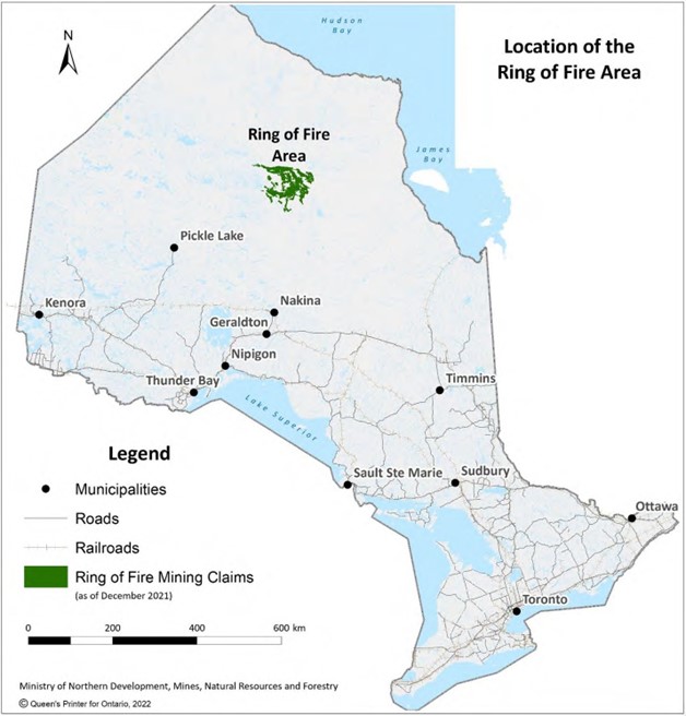
Discovered in the early 21st century, the Ring of Fire is considered one of the most significant mineral deposits in Canada, with the potential to positively impact the nation’s economy and global mining industry.
The Ring of Fire region is also one of the most promising mineral development opportunities for critical minerals in the province. While there is no universal definition of critical minerals and various jurisdictions define them differently, the term generally applies to minerals that have specific industrial, technological and strategic applications for which there are few viable substitutions. The Ring of Fire contains significant critical mineral deposits including nickel, copper, platinum and chromite, which are needed for such products as computer monitors, smartphones and electric vehicle batteries. In March 2022, the province released its Ontario’s Critical Mineral Strategy (the Strategy, https://www.ontario.ca/page/ontarios-critical-minerals-strategy-2022-2027-unlocking-potential-drive-economic-recovery-
prosperity) with a vision for Ontario’s mining sector to transform into a leading producer of critical minerals. The Strategy is a comprehensive, five-year roadmap that is intended to secure the province’s position as a reliable global supplier of responsibly sourced critical minerals. The strategy highlights the Ring of Fire region as transformative opportunity for unlocking multi-generational development of critical minerals and Ontario efforts to collaborate with First Nations partners on legacy infrastructure development in northern Ontario, who see potential Ring of Fire developments as opportunities for prosperity.
In addition to the mining context and potential economic development benefits of linking Webequie First Nation to the mineralized zone, the proposed WSR is also relevant in the context of broader, long-term provincial growth, development and multimodal transportation initiatives in the region.
The key provincial plans and government priority initiatives around regional infrastructure include the following:
- Ontario’s Infrastructure Building Better Lives: Ontario’s Long-Term Infrastructure Plan 2017 (MOI, 2018);
- The 2041 Northern Ontario Multimodal Transportation Strategy (Draft) (MTO and MNDM, 2017);
- The Growth Plan for Northern Ontario (MOI and MNDMF, 2011); and
- Ontario’s Mineral Development Strategy (MNDM, 2015).
Ontario’s Infrastructure Building Better Lives: Ontario’s Long-Term Infrastructure Plan 2017 (MOI, 2018), “Infrastructure Plan”), acknowledges that communities in northern Ontario are in need of a multimodal transportation system and that the north is especially vulnerable to the impacts of climate change, particularly in communities that rely on seasonal winter roads, such as Webequie First Nation. The Infrastructure Plan is intended to address the problem of unreliable community access and the province is working with First Nations to plan and construct all-season access roads for connecting communities to the existing provincial highway system. Should the WSR, NRL and MFCAR Projects proceed they will connect Webequie First Nation to the provincial highway system and provide potential economic opportunities and social benefits to Webequie and other Indigenous and non-Indigenous communities, which support the government’s commitment to create jobs, provide long-term benefits and improve the quality of life for people in the region.
The focus on implementation of an all-season road route is also further supported by a number of other provincial government plans that include policies and initiatives for an improved transportation system and community access in northern Ontario. The Growth Plan for Northern Ontario (Growth Plan; MOI and MNDMF, 2011) outlines the province’s commitment to work with remote communities for improved access. To implement the transportation directions of the Growth Plan, the Ontario Ministry Transportation (MTO) and the Ministry of Mines are also developing a 2041 Northern Ontario Multimodal Transportation Strategy, which recognizes that there is a uniquely close linkage between transportation and the quality of life and economic vibrancy in northern Ontario; and that flexible and innovative strategic direction is required to enhance transportation reliability and communications to and from remote communities, who’s primary means of access (air travel, winter ice roads) are limited.
From the perspective of Webequie First Nation, the WSR could be constructed and operated as a facility that only provides a connection between Webequie First Nation and the McFaulds Lake area to serve mineral exploration and future mining development activities, with no connection to the provincial highway system. However, with implementation of the Project and should future mining and other road projects (i.e., NRL and MFCAR) proceed to the McFaulds Lake area, Webequie First Nation would gain year-round access to the provincial highway system. It is in this scenario that the socio-economic effects of the WSR Project would likely be realized or felt to the fullest. The EA/IA for each of the WSR, NRL, and MFCAR assesses potential socio-economic effects of these separate projects as well as their potential cumulative effects, should these road projects proceed.
1.4 Legislative and Regulatory Framework
The Project requires provincial and federal regulatory approvals and authorizations as discussed in the following sub-sections.
1.4.1 Ontario Environmental Assessment Act
The Ontario EA Act embodies and enables a planning and decision-making process to ensure the protection, conservation, and wise management of the environment.
Projects can be classified as falling under either a Class Environmental Assessment process or a Comprehensive Environmental Assessment process.
Class Environmental Assessments apply to those projects that are deemed approved subject to compliance with an approved standardized planning process. This standardized planning process is for classes or groups of projects that are carried out routinely and have predictable environmental effects that can be largely mitigated. No formal approval under the EA Act is required, provided the procedural requirements of Class EA parent documents are followed, and the project is not subject to Section 16 order request to the Ontario MECP to make the Project subject to Part II.3 of the EA Act (the preparation of a Comprehensive EA). The Class Environmental Assessment for Resource Stewardship and Facility Development Projects (RSFD) (Amended 2024, “MNR RSFD Class EA”) generally applies to many types of projects where a disposition of lands and/or resources from MNR is required, like the Webequie Supply Road. The Class EA approach affords efficiencies by grouping projects with similar characteristics, and by following a pre- approved, predictable process.
Comprehensive Environmental Assessments are completed for those projects that are complex in nature, with the potential for significant environmental effects and require a decision by the MECP under the EA Act. The Project is following a Comprehensive Environmental Assessment process.
The scope and scale of the proposed Project (i.e., the length, significance and potential impacts, along with the related activities (e.g., aggregate extraction)), were expected to be outside of the intended scope of the MNR RSFD Class EA, and the use of the Class EA could potentially fail to address the complexities that could reasonably be anticipated to arise for an all-season road of this length in a remote northern environment. Consequently, Webequie entered into a voluntary agreement with MECP under Section 3.0.1 of the EA Act to make the Project subject to the Act, as the Comprehensive EA process was considered to be more appropriate for effectively addressing the scale, complexity and potential for significant environmental effects. MNR advised MECP and Webequie First Nation that assuming there are no deficiencies or gaps in the preparation of the Comprehensive EA, the Comprehensive EA should address MNR’s RSFD Class EA requirements. Therefore, it is Webequie’s intent to satisfy the MNR RSFD Class EA requirements through the Comprehensive EA process with any potential, future project changes falling under the appropriate processes relating to the Comprehensive EA.
The first step in a Comprehensive EA is the preparation, submission and MECP approval of a Terms of Reference (ToR). Webequie First Nation completed the process for the ToR approval, commencing with issuing a Notice of Commencement of ToR in January 2019 and releasing a Draft ToR for review in September 2019. Following engagement and consultation with Indigenous communities and groups, the public, government departments, ministries and agencies, and stakeholders, including both virtual and in-person community open houses and meetings, Webequie First Nation finalized a Proposed ToR, considering comments received on the Draft ToR. The Proposed ToR was submitted to the MECP in August 2020. The Proposed ToR identified a framework for the planning and decision-making process to be followed by Webequie First Nation during the preparation of the EA.
Following the review period of the Proposed ToR, MECP approved the ToR, with amendments, on October 8, 2021. The amendments in the ToR Notice of Approval contain additional requirements for consultation with Indigenous communities with respect to the cumulative effects assessment as part of the EA, and additional requirements for consultation with Indigenous communities at key milestones during the development of the EA. The amendments were informed by concerns with respect to potential adverse impacts to established or credibly asserted Aboriginal or Treaty Rights that were shared with the Crown during consultation with Indigenous communities, or that can reasonably be anticipated in the EA process.
The Notice of Approval of the ToR for the Project indicates that the EA pursuant to subsection 6.1(1) (now subsection
16.6 (1)) and subsection 6.2(1) (now subsection 17.7(1)) of the EA Act, must be prepared in accordance with the approved ToR. On November 3, 2021, the Notice of Commencement of EA was issued to formally start the EA stage of the process.
1.4.2 Canada Impact Assessment Act
The Project is subject to review under the federal IA Act, enacted June 21, 2019, which requires proponents of projects that are described in the Act’s Regulations Designating Physical Activities to prepare Initial and Detailed Project Descriptions1. “Physical Activities” subject to the Act are defined to include “the construction, operation, decommissioning and abandonment of a new all-season public highway that requires a total of 75 km or more of new ROW.” From the review of the Detailed Project Description, and the results of associated engagement and consultation activities, the Impact Assessment Agency of Canada (IAAC or “the Agency”) issued a Notice of Decision to Webequie First Nation on December 2, 2019 that a federal IA is required for the Project under the IA Act based on the potential for adverse effects within federal jurisdiction, including fish and fish habitat, migratory birds, and changes to the health, social, economic and environmental conditions of Indigenous Peoples. The Agency also in their decision noted that the Project may also adversely impact the rights of several Indigenous groups, including Indigenous groups who are signatories to Treaty 9.
Following the determination that a federal IA was required, the Agency as part of the planning phase of the IA process developed the following planning documents for the Project:
- Tailored Impact Statement Guidelines (TISG) (2020);
- Indigenous Engagement and Partnership Plan (2020);
- Public Participation Plan (2020);
- Permitting Plan (2020); and
- Cooperation Plan (2020).
1 The proposed Project was initiated under the Canadian Environmental Assessment Act, 2012. Based on the status of the Project Description when the IA Act came into force on August 28, 2019, the Project transitioned to the IA Act process at that time. “The IA Act replace Canadian Environmental Act (CEAA), 2012 and establishes an impact assessment process to serve as a project planning tool, which takes into consideration the whole range of environmental, health, social and economic effects of projects. The new regime shifts away from decisions based solely on the significance of adverse environmental effects and will focus instead on whether the adverse effects in areas of federal jurisdiction are in the public interest.” (Canada Gazette_g2-15317, August 21, 2019).
The purpose of the IA planning documents is to identify the scope of the factors that are to be considered by the proponent in its IS and guide engagement and consultation on the Project. As part of the IA planning phase the Agency provided opportunities for Indigenous communities and the public to provide comments on the draft IA planning documents. Based on review of comments received the Agency posted a Notice of Commencement of the IA for the Project to their Registry on February 24, 2020, including the final TISG and supportive plans. This step concluded the planning phase and the Project is now in the IS phase of the federal IA process.
For the IS phase Webequie First Nation as the proponent has three years to prepare and submit to the Agency a satisfactory Impact Statement in accordance with the TISG. Based on the issuance of the Notice of Commencement of the IA on February 24, 2020, the legislated time limit to provide the Agency with a satisfactory IS for the Project was February 24, 2023.
The COVID-19 global pandemic that began in March 2020 introduced significant challenges to the execution of the
IA process for the Project and meeting the timeline to complete a satisfactory IS by February 24, 2023. Key challenges included a delay in conducting field surveys to collect baseline data for biophysical aspects of the environment and ability to complete face-to-face engagement and consultation activities with Indigenous communities and groups, the public, government departments, ministries and agencies, and stakeholders as they entered isolation and/or gathering restrictions during COVID-19. In accordance with subsection 19(2) of the IA Act, the Agency can extend the time limit by any period that is necessary for a proponent to provide the Agency with the information or studies (i.e., IS). On August 9, 2022, Webequie First Nation requested the Agency consider an extension to the three-year time limit from February 24, 2023 for the Project under the IA Act to January 6, 2027. Following a review of the information submitted by Webequie First Nation, the Agency under subsection 19(2) of the IA Act granted the requested extension to the
IS phase of the Project on January 5, 2023.
Once the Agency is satisfied with the content of the IS prepared by the proponent, the 300-day Impact Assessment phase of the IA process begins, and the Agency prepares a draft Impact Assessment Report (IAR). The Agency considers comments received on the draft IAR, finalizes the IAR and potential conditions, and provides the IAR, potential conditions and Consultation Report to the Minister of Environment and Climate Change for a decision.
The status of the IA Act process for the Project can be accessed through the following link: https://iaac- aeic.gc.ca/050/evaluations/proj/80183.
On October 26, 2023 in response to the Supreme Court of Canada’s decision on the constitutionality of the IA Act, the Agency shared the Government of Canada’s Statement on the Interim Administration of the IA Act Pending Legislative Amendments with Webequie First Nation to provide guidance until targeted and meaningful amendments to the IA Act were made. On June 20, 2024, the Budget Implementation Act, 2024, No. 1, received Royal Assent and brought into force amendments to the IA Act. On July 15, 2024 the Agency notified Webequie First Nation, as the proponent of WSR, of the key amendments to the IA Act including the transitional provisions relevant to the Project. In the letter of July 2024, the Agency confirmed that the Project may result in adverse effects within federal jurisdiction, as defined in the amended IA Act, and will remain subject to the amended IA Act.
On a matter also related to the IA Act, the Minister of Environment and Climate Change received three requests for a regional assessment in the area centered on the Ring of Fire mineral deposits in northern Ontario. On February 10, 2020, the Minister granted the requests for conducting a regional assessment with the intent for the Agency to work with the Province of Ontario, Indigenous communities and groups, federal authorities, non-government organizations and the public to determine the appropriate activities, outcomes and boundaries of the regional assessment. Since that time on-going analysis and planning work by the Agency has been conducted, including public information sessions and engagement activities in 2020, 2021 and 2022. This included making Participant Funding available. On May 11, 2023, it was announced that the Minister met with Indigenous leadership from Matawa and Mushkegowuk Territories in
January 2023 and committed to working together to co-develop and co-lead a focused regional assessment under a ToR that is prepared in partnership to reflect the priorities of Indigenous communities and the Agency. On September,4, 2024 the Agency posted a notice that Indigenous communities from Matawa and Mushkegowuk Territories and the Agency are co-leading the Regional Assessment in the Ring of Fire Area and offered Indigenous communities, organizations, and peoples, as well as the public an invitation to review and provide feedback on the draft Terms of Reference.
The Regional Assessment in the Ring of Fire Area (IAAC, 2023) is independent of the EA/IA for the WSR and other IAs in the region and is a separate federal assessment process. As required by the TISG for the WSR Project, and the IA Act, relevant information from the regional assessment, if available, will be used to inform the Project effects assessment. This may, for example, include informing the baseline studies, effects prediction, cumulative effects assessment, mitigation and enhancement measures, and follow-up programs, as applicable.
1.4.3 Process for Federal-Provincial Coordination
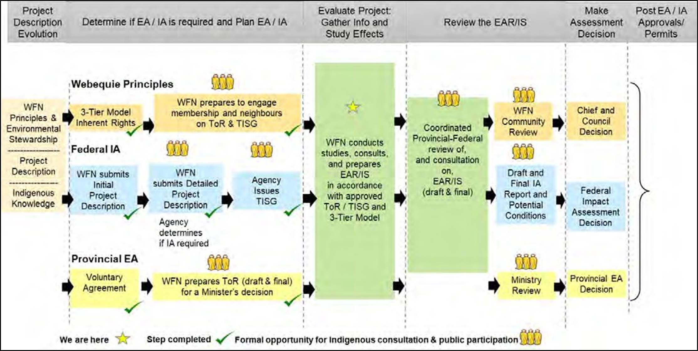
The Project is subject to both the Ontario EA Act and the federal IA Act. The requirements of the Acts and the process to execute the assessments differ somewhat, as displayed in Figure 1.4 below. As the steps in an EA required by MECP and IA by the Agency differ, a coordinated approach is needed to meet the requirements of the federal and provincial processes. In addition, the Webequie Three-Tier framework for consultation (refer to Section 1.2.3 and Section 2) is being incorporated in the EA/IA process. To guide this coordinated process, Canada and Ontario entered into an agreement entitled “Canada-Ontario Agreement on Environmental Assessment Cooperation” (2004). For the Project, the two levels of government have indicated a willingness to follow a coordinated assessment process to the extent possible, and for the proponent to produce one body of documentation, referred to as the EAR/IS. As such, this EAR/IS addresses the requirements of both the provincial ToR and the federal TISG. To help facilitate a coordinated process, an EA Coordination Team has been established for the Project and includes representatives of both the federal and provincial governments. The purpose of this team is to address and coordinate the requirements of both processes in an efficient manner.
The EA Coordination Team is comprised of the following provincial and federal agencies:
- Ontario Ministry of Mines;
- Ontario Ministry of the Environment, Conservation and Parks;
- Ontario Ministry of Natural Resources;
- Ontario Ministry of Transportation; and
- Impact Assessment Agency of Canada.
Further details on the mandate of the EA Coordination Team is described in Section 2.2.2.1.
As part of the coordinated federal-provincial EA/IA process, the Webequie Supply Road assessment will include the following process milestones, as presented in Figure 1.4:
- Pre-EA Planning, including signing of the voluntary agreement between Ontario and Webequie First Nation to participate in the process, development of the ToR and Agency issuance of the TISG;
- EA/IA commencement;
- Environmental baseline studies, consultation and preparation of the EAR/IS;
- EA and IA decisions; and
- Monitoring and follow-up.
Figure 1.4: Coordinated Webequie-Federal-Provincial EA/IA Process
1.4.4 Other Relevant Federal Permits and Approvals
In addition to the IA Act, the Project may require permits and approvals under the federal legislation identified in Table 1-2. Table 1-2: Federal Legislation, Permits, and Other Authorizations
| Federal Agency | Legislation/Permit/Act | Applicability to the Project |
| Transport Canada | Canadian Navigable Waters Act | Consult with Transport Canada on any work in or over a navigable waterbody that may interfere substantially with navigation (e.g., construction of a bridge, boom, dam or causeway, dumping of fill in or excavation of materials from the riverbed, placement of any power cable, wire, structure or device). There are no crossings of waterbodies for the WSR that are listed in the Schedule to the Act designating Navigable Waters, but there will be major, minor and other works on unlisted waterways deemed to be navigable that will be subject to the Act’s provisions. |
| Fisheries and Oceans Canada | Authorization under Fisheries Act | Authorization may be required for construction and/or operation activities if the activity is determined to cause death of fish and/or the harmful alteration, disruption, and/or destruction to fish habitat. This applies to work being conducted in or near waterbodies that directly or indirectly support fish. |
| Environment and Climate Change Canada | Permit under Species at Risk Act (2002) Section 73 | Required if Project construction and/or operations cause impact to a terrestrial, avian or aquatic species listed under Species at Risk Act Schedule 1, or its habitat, and which contravenes the Act’s general or critical habitat prohibitions (includes intrusive methods for sampling, e.g., electrofishing). |
| Federal Agency | Legislation/Permit/Act | Applicability to the Project |
| Indigenous Services Canada (ISC) | Authorization under Indian Act Section 28(2) | For components of the Project ISC must authorize the occupation of, use of, residency on, or exercise of rights on First Nations Reserve lands: “The Minister may by permit in writing authorize any person for a period not exceeding one year, or with the consent of the council of the Band for any longer period, to occupy or use a reserve or to reside or otherwise exercise rights on a reserve.” Portions of the road route and supportive infrastructure (e.g., aggregate areas) would be located on First Nation Reserve lands. |
| Natural Resources Canada | Blasting Explosives Purchase and Possession Permit Transportation of Explosives Permit under the Explosives Act | Required for the purchase use, storage or transportation of explosives. |
1.4.5 Other Relevant Provincial Permits and Approvals
In addition to the EA Act, the Project may require permits and approvals under the provincial legislation identified in
Table 1-3: Provincial Legislation, Permits, and Other Authorizations
| Agency | Permit/Act | Applicability to the Project |
| Ontario Ministry of Natural Resources (MNR) | Permit to Collect Fish for Scientific Purpose under the Fish and Wildlife Conservation Act (1997) | To facilitate the capture and transfer of fish during in-water works, such as cofferdam construction or dewatering. |
| MNR | Permit to Collect Wildlife for Scientific Purpose under the Fish and Wildlife Conservation Act (1997) | Facilitates the capture and transfer of wildlife. |
| MNR | Authorization under the Fish and Wildlife Conservation Act (1997) | Require should Project construction and operation activities destroy the nests or eggs of birds, a beaver dam, or the den of a black bear or some furbearing mammals or interfere with a black bear in its den. |
| MNR | Forest Resource Licence (Cutting Permit) under the Crown Forest Sustainability Act (1994) | Required to harvest and/or cutting timber on Crown land. |
| MNR | Burn Permit under Forest Fires Prevention Act (1990) | Required for burning of materials from forest clearing, if required. |
| Agency | Permit/Act | Applicability to the Project |
| MNR | Public Lands Act (1990) Work Permit | Works on Crown lands and/or shore lands, including geotechnical investigations, construction/upgrade of access roads, trails and culverts/bridges.The majority of the Project components would require a Work Permit under the Act. |
| MNR | Land Use Permit | Required to provide Occupational Authority for the road ROW including access roads to and within project site, temporary construction camps and/or laydown areas. |
| MNR | Far North Act (2010) | On December 9, 2021, changes to the Far North Act, 2010 were approved in Schedule 10 to Bill 43, the Build Ontario Act (Budget Measures) 2021. These changes are intended to encourage collaboration between Ontario and First Nations on land use planning and foster economic growth in the Far North while maintaining critical cultural and environmental protections. At this time no authorization or Lieutenant Governor In Council or Minsters Order under the Far North Act is required for the Project. |
| MNR | Aggregate Permit under Aggregate Resources Act (1990) | Required for extracting aggregate on all Crown land and on private land in areas of the province designated (specifically identified) in the regulations. |
| MNR | Work Permit under Lakes and Rivers Improvement Act (LRIA) | Required for water crossing on private lands (channelization, diversions, bridges, culverts). |
| Ontario Ministry of the Environment, Conservation and Parks (MECP) | Permit to Take Water or Environmental Activity and Sector Registration (EASR) under the Ontario Water Resources Act (1990) | Where project construction requires water taking – pumping, draining, dewatering, wells.Takings up to 50,000 litres per day (L/Day) require no permit/registration.Dependent upon meeting specific criteria (e.g., water source, purpose, etc.) of the Water Taking EASR Regulation – O. Reg. 63/16, some takings between 50,000 L/day and 400,000 L/day may qualify for registry (EASR), while other takings (e.g., associated with aggregate pit) may require a permits to take water (PTTW.)Takings over 400,000 L/day require a permit (PTTW). |
| MECP | Authorization under the Endangered Species Act, 2007 | Required if Project construction and/or operations have effects on listed species or habitat. |
| MECP | Approval under Health Protection and Promotion Act (1990) | Facilitates provision of potable water and on-site sewage treatment and disposal systems at temporary construction camp(s). |
| Agency | Permit/Act | Applicability to the Project |
| MECP | Environmental Compliance Approval under Environmental Protection Act (1990) | Enables waste to be transported by haulers from the project work site and enables emissions from on-site equipment.An Environmental Compliance Approvals (ECA) may be required for the discharge and treatment of wastewater generated from some water takings.An ECA will be required for aggregate wash water systems with capacity greater than 10,000 L/Day.An ECA will be required for on-site sewage systems with a design capacity in excess of 10,000 L/Day.An ECA, or Air and Noise EASR, will be required for activities related to noise and air impacts resulting from aggregate extraction and/or construction camps.An ECA will be required for isolated power generation at construction camps and/or permanent maintenance facility where a connection to grid service is not available.A Generator Registration Number may be required the event hazardous and liquid industrial wastes are generated during project construction. |
| Ontario Ministry of Health | Permit to Construct – Sewage System | A district Health Unit permit will be required for on- site sewage systems with a design capacity of up to 10,000 L/Day. |
| Ontario Ministry of Labour, Immigration, Training and Skills Development | Occupational Health and Safety Act (1990) | Notice of Project under Section 23(2) prior to construction and/or to provide notice of opening of construction camp. |
| Ministry of Mines | Mining Act | Required to withdraw lands from prospecting and withdrawal of staking rights under the Mining Act. |
| Ministry of Citizenship and Multiculturalism | Ontario Heritage Act (1990): Part III.1 (Standards and Guidelines for Conservation of Provincial Heritage Properties) Part VI (Archaeological Resources) Standards and Guidelines for Consultant Archaeologists O. Reg. 9/06: Criteria for Determining Cultural Heritage Value or Interest | Archaeological assessment to be conducted as part of the EA under the Ontario Heritage Act (1990) and submitted to the Ontario Public Register of Archaeological Reports. An Archaeology License issued under the Ontario Heritage Act is required to conduct archaeological assessments and to alter archaeological sites in Ontario. Built heritage and cultural heritage landscape screening and, where required, heritage impact assessments under Ontario’s EA Act and in compliance with the Standards and Guidelines for Conservation of Provincial Heritage Properties. |
1.5 Report Organization and Presentation
The EAR/IS is presented in the following sections.
- Table of Contents – includes lists of sections, subsections, Figures, Tables, and Appendices.
- Glossary of Terms used in the EAR/IS.
- Acronyms and Abbreviations used in the EAR/IS.
- Section 1: Introduction – provides an overview of the Project, the proponent, the historical context and project rationale, the regulatory framework, and organization of the EAR/IS.
- Section 2: Engagement and Consultation – provides a summary of engagement and consultation with Indigenous communities and groups, the public, government departments, ministries and agencies, and stakeholders.
- Section 3: Evaluation of Project Alternatives – describes and evaluates alternatives considered for the Project and describe the process for selecting preferred alternatives.
- Section 4: Project Description – describes the scope of the proposed Project, project components, estimated cost, project phases and activities, the project schedule, and project workforce requirements.
- Section 5: Environmental Effects Assessment Approach – includes an overview of the effects assessment approach and the scope of the EA/IA.
- Sections 6 to 20: Assessment of Effects on Valued Components – provides a description of the existing conditions for the following valued components (VCs) and identifies potential effects of the Project on these VCs, mitigation to eliminate or reduce potential effects or enhancement measures to enhance or prolong potential project benefits, net effects following implementation of mitigation, and determination of the significance of any net effects.
- Geology, Terrain and Soils (Section 6);
- Surface Water Resources (Section 7);
- Groundwater Resources (Section 8);
- Atmospheric Environment (Section 9);
- Fish and Fish Habitat (Section 10);
- Vegetation and Wetlands (Section 11);
- Wildlife and Wildlife Habitat (Section 12);
- Species at Risk (Section 13);
- Social Environment (Section 14);
- Economic Environment (Section 15);
- Non-Traditional Land and Resource Use (Section 16);
- Human Health (Section 17);
- Visual Environment (Section 18);
- Aboriginal and Treaty Right and Interests (Section 19); and
- Cultural Heritage and Archaeological Resources (Section 20).
- Section 21: Cumulative Effects Assessment – provides a description of the cumulative effects assessment methodology, and assesses predicted net effects of the Project in combination with effects from other past, present and future physical activities.
- Section 22: Follow-Up and Monitoring – describes the program designed to verify the accuracy of the effects assessment, evaluate the effectiveness of mitigation measures, as well as to conduct compliance monitoring of the obligations or commitments made during the EA/IA process.
- Section 23: Accidents and Malfunctions – describes potential adverse effects of accidents or malfunctions that may occur over the life of the Project and mitigation, safety and preventive measures, and emergency measures in response to accident or malfunction events.
- Section 24: Effects of the Environment on the Project – describes potential effects that may occur as a result of the environment forces or hazards acting on the Project and identifies mitigation measures to eliminate or reduce potential adverse effects.
- Section 25: Project Effects on Canada’s Ability to Meet its Environmental Obligations and its Climate Change Commitments – describes the extent to which the effects of the Project hinder or contribute to the Government of Canada’s ability to meets its environmental obligations, and its commitments in respect to climate change.
- Section 26: Project Contributions to Sustainability – characterizes the Project’s contribution to sustainability by examining how the sustainability principles were applied to the Project.
- Section 27: Summary of the Assessment – provides a summary of the EAR/IS and a statement of key conclusions.
- Appendices include tables of concordance with the TISG and provincial EA ToR, and technical reports and baseline studies conducted for the Project.
1.6 References
Archaeological Services Inc. (ASI). 2021. Cultural Heritage Report – Preliminary Desktop Data Collection Results – Webequie Supply Road – Draft Report. Internal Document Review.
Canadian Broadcasting Corporation (CBC). 2023. Original Voices: OJI-CREE-CBC. Retrieved May 3, 2023. Available: https://www.cbc.ca/newsinteractives/original-voices/oji-cree.
Crown-Indigenous Relations and Northern Affairs Canada (CIRNAC). 2023. First Nation Detail – Webequie. Retrieved June 6, 2023. URL: https://fnp-ppn.aadnc- aandc.gc.ca/fnp/Main/Search/FNMain.aspx?BAND_NUMBER=240&lang=eng
Government of Ontario. Ministry of Energy, Northern Development and Mines. 2021. Ontario Critical Minerals Framework Discussion Paper. Accessed at https://ero.ontario.ca/notice/019-3281Environment and Climate Change Canada (ECCC). 2020. Strategic Assessment of Climate Change. Revised October 2020. Accessed January 2023. URL: https://www.strategicassessmentclimatechange.ca/
Government of Canada. 2022. First Nation Detail – Webequie. Accessed January 2023. URL: https://fnp-ppn.aadnc- aandc.gc.ca/fnp/Main/Search/FNMain.aspx?BAND_NUMBER=240&lang=eng
Government of Ontario. Ministry of Northern Development, Mines and Natural Resources and Forestry. 2022. Ontario’s Critical Minerals Strategy – Unlocking potential to drive economic recovery and prosperity 2022-2027. Accessed at https://www.ontario.ca/page/ontarios-critical-minerals-strategy-2022-2027-unlocking-potential-drive-economic- recovery-prosperity.
Impact Assessment Agency of Canada (IAAC). 2020. Webequie Supply Road Project – Tailored Impact Statement Guidelines. Available at: https://iaac-aeic.gc.ca/050/evaluations/document/133938?culture=en-CA
Impact Assessment Agency of Canada (IAAC). 2023. Regional Assessment in the Ring of Fire Area. Accessed May 30, 2024. Available: https://www.iaac-aeic.gc.ca/050/evaluations/proj/80468
Indigenous Services Canada (ISC). 2023. Leadership selection in self-governing First Nations. Accessed June 2023.
Available: https://sac-isc.gc.ca/eng/1323195944486/1565366893158
Ministry of Infrastructure (MOI) and Ministry of Northern Development, Mines and Forestry (MNDMF). 2011. Growth Plan for Northern Ontario. Accessed January 2023. URL: https://www.ontario.ca/document/growth-plan-northern- ontario
Ministry of Infrastructure (MOI). 2018. Building better lives: Ontario’s Long-Term Infrastructure Plan 2017. Accessed January 2023. URL: https://www.ontario.ca/document/building-better-lives-ontarios-long-term-infrastructure-plan- 2017/?_ga=2.64299183.1440658338.1585162086-1230834809.1566852703
Ministry of Northern Development and Mines (MNDM). 2015. Ontario’s Mineral Development Strategy. Accessed November 2019. URL: http://www.mndm.gov.on.ca/sites/default/files/2006_mineral_development_strategy_english_-
_2014_oada_compliant_version.pdf
Ministry of Transportation (MTO) and Ministry of Northern Development and Mines (MNDM). 2017. DRAFT 2041 Northern Ontario Multimodal Transportation Strategy. Accessed January 2023.
URL: https://northernontariommts.files.wordpress.com/2017/07/draft-northern-ontario-multimodal-transportation- strategy1.pdf
Nishnawbe Aski Nation. (2023). First Nations in Nishnawbe Aski Nation. Retrieved June 8, 2023.
URL: https://www.nan.ca/about/first-nations/
Ontario Mining Association. 2022. State of the Ontario Mining Sector. Accessed June 2023. URL: https://oma.on.ca/en/ontario-mining/2022_OMA_Economic_Research_Report.pdf
Webequie First Nation. 2019. Webequie First Nation Community Based Land Use Plan. Webequie Anishininniwuk Ahki Ohnahchiikaywin. V. 4.3. Draft. March 2019. Internal Document Review.
Webequie First Nation. 2023a. Name and Logo. Webequie First Nation. Retrieved June 23, 2023. URL: http://www.webequie.ca/article/name-and-logo-119.asp.
Webequie First Nation. 2023b. Governance. Webequie First Nation. Retrieved June 23, 2023. URL: http://www.webequie.ca/article/governance-130.asp.
AtkinsRéalis
191 The West Mall Toronto, ON M9C 5L6 Canada
416.252.5315
atkinsrealis.com
© AtkinsRéalis except where stated otherwise